Portaferry
A small town with a rich history

A grand day out
Outstanding scenery, and a rich and rare history waiting for you to explore
Portaferry is a friendly little town perched at the edge of the narrows that separate the Ards Peninsula from the 'mainland' Lecale. From the shorefront you can see the little village of Strangford perched on the opposite shore.
Portaferry is home to the Portico Arts & Heritage venue, Exploris Aquarium, a Norman castle, and a fine Georgian market house.
And while you're there, make the effort to drive up Windmill Hill to enjoy breath-taking panoramic views of County Down, Strangford Lough, and the Irish Sea.
Places worth visiting nearby
These are just a few of the interesting places waiting for you to explore in and around Portaferry

Market House
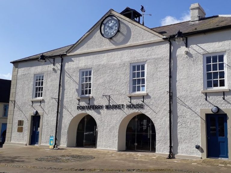
In the town square is this imposing Georgian building, completed in 1752 by local landowner Andrew Savage of Portaferry House.
This market house hosted markets, dances and gathering; and, upstairs were library rooms for the Literary Society, and the Mechanical Institute Library.
The centre room was also used as manor court.
The Market House has a weather vane, two clocks, and a sundail; and it remains in regular use by the local community.

Exploris Aquarium
The completely redeveloped and remodeled centre – which still includes a famous aquarium, educational open pools in the ‘Strangford Vikings’ and kids’ zone as well as the seal sanctuary – now boasts a reptile section and exciting additions to their deep-sea exhibit.
Get an even closer look at these majestic animals which inhabit the surrounding waters of Strangford Lough - a designated Area of Outstanding Natural Beauty and an Area of Specific Scientific Interest - with our guided tours and scheduled feeding sessions from above or below the water line.
A great experience for all ages, including cafe restaurant, and souvenir shop.

Portico
Originally home to what is believed to have been the earliest Presbyterian congregation in Ireland, this fine church building is now home to an arts venue.
Located near the square on Meetinghouse Street, Portico is a multi-purpose venue for everyone to use.
It will host cultural, educational and heritage events and activities to include film shows, concerts, exhibitions, literary events, talks and much more. The Meeting Room and Auditorium can be hired for public events such as concerts or conferences, or privately for weddings, funerals or family events.
Or, if you prefer, you can worship here on Sunday mornings with the local Presbyterian church.

Templecranny Church
These visible ruins date from the 1600s; however, it is known that this is the site is in a round shape that is typical of early Celtic religious settlements, and could be as early as 8th century.
Portaferry is the site of the earliest Presbyterian congregation in Ireland, and this church building was used by them during the post-reformation period. Many of the gravestones record the burial of Scottish planters.
In 1662 the church building was appropriated by the Anglican church, and it remained their place of worship until a new parish church, St James' [or Ballyphilip] Church of Ireland was built directly across the road in the 1780's.

Portaferry House
This is a private residence, not open to public viewing; however, you can catch a glimpse of it through the trees when you walk between the Rope Walk car park and old Templecranny Church.
This fine Georgian country house was built around 1760 by Andrew Savage, a Captain in the First Battalion of the Regimento de Infantrerie de Hibernia, of the Spanish Army of King Philip V of Spain.
Andrew Savage extended the house with a west wing, completed in 1818, which was paid for from the winnings of a bet he made with Robert Stewart of Mount Stewart.
The Savage family is descended from William Savage who arrived in these parts with Sir John de Courcy in 1177, and the family remained here for 700 years.
The family name was changed in 1814 to Nugent, when Andrew Savage inherited a portion of the fortune of his great-uncle, Governor John Nugent of Westmeath.
The family line came to an end during WWII when both sons to Roland Nugent were killed in action: the elder, [22] killed in Tunisia in 1941; the younger [19] killed in Italy 1942. Both sons were lieutenants in their father's regiment, the Grenadier Guards.
Following the death of Mrs Nugent in 1986, the house was sold and developed as appartments.

Windmill Hill
Enjoy stunning panoramic views across Strangford Lough and all around as far as the Isle of Man and Scotland, certainly worth the effort.
The old windmill stump is accessible, and you can climb to the top and peep through one of the little windows. But excellent views can also be enjoyed from the roadside.
Location: you can see it from the town, it's the high hill with a windmill stump on it just a short distance to the south.
Access: accessible by foot and vehicle; there is a small lay-by at the summit of the road with a viewing point.

Strangford Ferry
The powerful 9-knot tidal current between Portaferry and Strangford village was given its name by Viking settlers, who named the waters strang fjord, meaning 'fjord of the strong current'.
The maximum depth of waters here is 52-metres, and it is estimated that 350-million cubic metres of water gush in and out through the Narrows with each tide.
The ferry service has been provided here continuously for over 400-years, since 1612, when King James I granted a covenant to Peter Tumolton to for ever maintain, keep and have in readiness, in and upon the ferry of Strangford, a good strong and sufficient ferryboat,...
In 1836 this crossing was serviced by the first steam ferry in Ireland, when Lady of the Lake took up service; the first passengers were the newly-married daughter of Andrew Nugent [of Portaferry House] and her husband James Stronge of Tynan Abbey, Armagh.
The new ferry cost £6.2-million, and came into service in 2017. The older ferry [used as a spare] was built in 1969.
Sailing every fifteen minutes from one side to the other, this is a great way to enjoy views of the lough and the offshore views of Portaferry and Strangford village. You don't have to take your car: travel as a foot passenger and get the wind in your hair.
And during the summer months, the ferry is often escorted by dolphins skimming the wake.

Wreck of SS Empire Tana
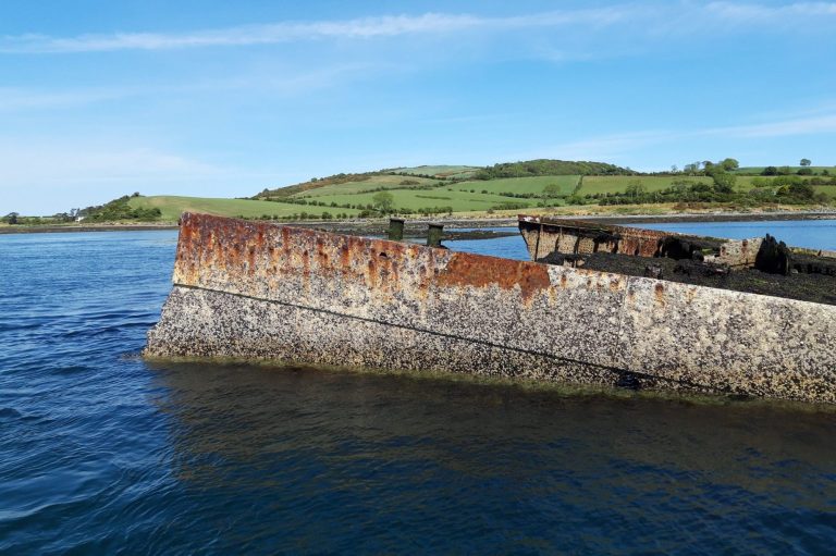
Visible at most levels of the tide close to Ballyhenry Island, this ship was originally Italian, captured by the Allies during WWII, and used as part of the Gooseberry Breakwater on SWORD Beach following the D-Day Normandy landings.
While under tow to be processed for scrap, the vessel hit rocks and broke in two. It is now a haven for a diverse range of marine life, and is very popular with SCUBA divers.

Ballyquintin Farm
This grassland walk is situated at the very tip of the Ards Peninsula at the mouth of Strangford Lough. The coastal path passes through farmland, rocky shore and beach owned and managed by the National Trust, and also through a National Nature Reserve owned and managed by the Environment & Heritage Service. From the walk you can take in views across Strangford Lough to Killard Point and across the Irish sea to The Isle of Man on a clear day. Bird species to look out include skylarks, linnets, peregrine falcons, buzzards, kestrals and Brent geese. The site consists of coastal grassland, a habitat which includes some sensitive and rare flowers including orchids and wind- dwarfed Burnett rose. Also look out for Irish hares and common seals which can be seen on the rocks at the mouth of Bar Hall Bay.

Derry Churches
These ruined churches are situated one and a half miles north east of Portaferry on the Tullymally Road, east of the A20 to Cloughey and are signposted from Portaferry. Evidence dates these two small churches as being pre-Norman and are associated with Saint Cumain. A small early cross and carved stone are set in the larger church and may be viewed. Access is by a gate at the roadside and along a fenced path. There are no signposts at this entrance, and no layby for parking.

Kilwarlin Lighthouse
With the financial and lobbying support of Lord Kilwarlin, 2nd Marquis of Downshire, a grant of £1,400 was obtained to assist in the building of a lighthouse on the South Rock by resolution of the Irish House of Commons on 14 November 1783. However, it was not until 1793, ten years later, that construction began. The lighthouse was designed and built under the supervision of Thomas Rogers, lit for the first time on 25 March 1797 and named the 'Kilwarlin Light' in honour of the Marquis. Only two 'wave washed' lighthouses, the Eddystone and Bell Rock lighthouses, had been built earlier. The Belfast Newsletter of 19 July 1793 reported;'Mr Rogers an emininent artist has now begun the lighthouse on the South Rock, under the patronage of the Earl of Hillsborough. The several lighthouses now in the Kingdom have been viewed by Mr Rogers preparatory to their being improved'When construction of the Kilwarlin Lighthouse began in 1793 plans to use finished stone blocks from Wexford had to be abandoned after the first supply vessel sank on passage and the second was driven well off course onto the English coast. It was then decided to use local granite from a quarry near Newry, County Down, and a squad of 20 masons, 18 labourers, 2 smyths and 2 foremen were employed. They were based in the townland of Newcastle on the Ard's Peninsula (Note : not the town of Newcastle, County Down) where a masonary platform and a short quay was built, from where the construction materials were transported to the South Rock. The 'Kilwarlin Lighthouse' (or the South Rock Lighthouse) remained lit for 80 years, until 1 April 1877, when it was replaced by a manned light vessel, named the 'South Rock Light Vessel', positioned about 2 nautical miles further east of the Kilwarlin Light. The light vessel was eventually automated and the crew withdrawn on 31 March 1982.The lighthouse still stands.

Millin Bay
Located close to the bay shore is a Neolithic burial site which is over 5,000 years old. You can see the standing stones. The site was excavated in 1953 so there is quite a bit of information about it.
Location: try BT22 1QB on your SatNav, on the Irish Sea coast, take the shore road south from Quintin Bay: it is poorly signposted, half way along Millin Bay.
Access: park carefully on the road, and use the fenced pathway to the side of the private residence.

Saint Cooey's Wells
The recently restored Holy Wells at Tieveshilly are the site of his church, believed to date from the 7th Century. Temple Cowey is the ancient parish church of Witter but only the foundation stones, 54 x 24 feet, now remain. Nearby are the three Holy Wells – Washing, Eye and Drinking.
There is a good carpark, and [a lot of] steps down to the site.
From the wells, there is a little trail you can explore that leads onto the unspoilt rocky shore.
The Holy Well is signposted off the Ballyquintin Road - it's a bit tricky to find: try BT22 1RG on your SatNav and look out for a sign at a lane leading up a steep hill.
Gallery
Directions
Follow the A20 south from anywhere on the Ards Peninsula, and follow the signposts to Portaferry; it is the southernmost town on the peninsula.
We need your consent to load the translations
We use a third-party service to translate the website content that may collect data about your activity. Please review the details in the privacy policy and accept the service to view the translations.


